

About This Location
.jpg) The Ten Mile Point Weather Station is located on the coastline of Ten Mile Point (NE of Cadboro Bay in Victoria, BC), positioned at the eastern
entrance of Baynes Channel and Haro Strait. It is sited to accurately measure the conditions on this busy waterway between Victoria and
the US San Juan Islands. Winds (and currents) accelerate as the channel narrows between the Point and Chatham Island, often creating unique local conditions
that can make a challenging passage for both sail and power boaters.
The Ten Mile Point Weather Station is located on the coastline of Ten Mile Point (NE of Cadboro Bay in Victoria, BC), positioned at the eastern
entrance of Baynes Channel and Haro Strait. It is sited to accurately measure the conditions on this busy waterway between Victoria and
the US San Juan Islands. Winds (and currents) accelerate as the channel narrows between the Point and Chatham Island, often creating unique local conditions
that can make a challenging passage for both sail and power boaters.
The water off the Point is a protected Marine Reserve, and is popular with scuba divers and kayakers. Sea life abounds; with many species of waterfowl, otters, seals, and orcas enjoying the rich upwelling waters.
About This Station
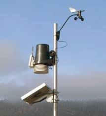 The weather station is a professional Vantage Pro2 station designed by Davis Instruments that measures wind speed and direction, barometric pressure, temperature, humidity, and rainfall. Data are transmitted via a wireless connection to a local server every 10 seconds, and then uploaded to the website. The wind anemometer is located on the coastline 45 feet above sea level, and has highly accurate direct measurement of sea breezes from the north, east and south.
About This Website
The Ten Mile Point website uses a modified version of Weather-Display weather software developed in New Zealand by Brian Hamilton.
Special thanks go to Ken True of Saratoga-Weather.org for the AJAX conditions display, dashboard and integration of the TNET Weather common PHP site design for this site.